
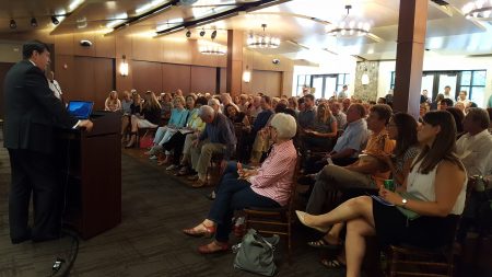
More than 150 residents showed up at Heritage Hall July 20 to preview a future Sandy Springs that has more mixed-use developments, better transit and improved green space.
The latest round of the city’s year-old “Next Ten” planning process updates included a draft of the new Comprehensive Plan along with the latest concepts for four “small area plans.” Those small area plans include the Roswell Road corridor, the city’s piece of Perimeter Center, Powers Ferry Landing and MARTA’s existing North Springs and possible future Northridge stations.
The general trends in all the plans were familiar from earlier drafts: ownership, middle-income housing in mixed-use settings, more street grids, better transportation alternatives and pedestrian-friendliness.
The Next Ten consultants will return with more refined plans for the Sandy Springs Festival in September and public meetings in October. City adoption of the plans is possible in November.
Meanwhile, draft plans and concepts are available for review and comment at thenext10.org.
Comprehensive Plan
The Comprehensive Plan is a 10-year city planning vision and policy document currently under major revision. It will help inform a totally new zoning code that is also in the works.
“The Comprehensive Plan is all about finding the right balance,” Next Ten consultant Deana Rhodeside told the City Council at another presentation on July 19. “It is about finding a sense of place that’s distinctly Sandy Springs.”
Plan is “implementation-oriented,” not something that will just sit on shelf, she said at the Heritage Hall meeting.
The draft Comp Plan contains 10 “key actions” for the city to perform:
- Create a new city Development Code
- Revitalize Roswell Road
- Transform Perimeter Center and Pill Hill into mixed-use, live-work areas
- Put high-density uses around MARTA stations
- Achieve a better housing balance in terms of types and income levels
- “Redesign Hammond Drive as an east/west connection”
- Mitigate traffic congestion through many alternatives
- Reduce parking requirements where alternatives are available and create MARTA-accessible “remote lots”
- Develop a trail network and fund at least one pedestrian bridge over the river
- Enhance and beautify the city’s public places
Roswell Road
This small area plan still calls for creating “a great boulevard as the city’s major north-south spine,” which means turning parts of Roswell Road into a tree-lined divided roadway with a grassy median.
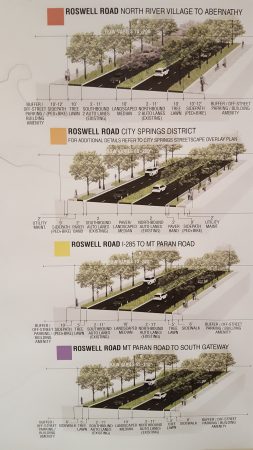
Three “nodes” of special attention within the plan are now the city’s City Springs redevelopment area, a “North River” area near the Roswell border, and an area around the Prado shopping center branded as “Crossroads.”
Among the goals is to create a special code for Roswell Road that shapes the form, density and other aspects of redevelopment along it.
Perimeter Center
The general idea is turning the city’s big business district into more of a street grid with elements that “reinforce the human scale.” Another goal: “Reinvent Peachtree-Dunwoody Road as an urban boulevard.”
Powers Ferry Landing
The Powers Ferry vision includes better pedestrian and bicycle connectivity to parks and retail areas. Among its ideas is an improved walkable “retail village” area south of I-285.
Other ideas include high-quality ownership townhomes and live-work projects in much of what is now the leafy office tower area along Riveredge Parkway. New green space could include a park-like “overbuild,” or deck, attached to the Northside Drive bridge over I-285.
The area also will be affected by future Braves stadium traffic, which has been a major city controversy. Assistant City Manager Bryant Poole told City Council July 19 that a dozen residents at a recent meeting about the Powers Ferry Landing concept supported most city ideas for managing Braves traffic. Those include a limited-use “slip ramp” to allow stadium-goers on 285 to access Interstate North Parkway without getting off at the Northside Drive interchange.
‘Missing middle’ of housing
Housing is a component of virtually every aspect of Next Ten planning, but a particular need for middle-income or “workforce” housing has come from public comments, Rhodeside said.
“Housing has emerged as a really critical issue,” she said, describing it as “the missing middle.” Unless more such housing is built, service workers and even city employees will struggle to live in the city’s expensive housing market, she said.
Parts of the draft land use plan indicate a method of finding some of that middle-class housing by encouraging the loss of low-income housing—older apartment buildings. In an interview during the meeting, Mayor Rusty Paul acknowledged that is part of the tactic, but added, “It’s not about removing anyone” and that he believes low-income-affordable housing will remain available in the city for a long time.
Middle-class housing, however, in is a dire shortage, the mayor said, describing that as increasing commuter traffic, blocking residents’ social mobility from poverty to affluence, and putting the housing market out of whack. “Not even our city manager or assistant city managers live here,” Paul said describing how the city’s housing expense can make it tough for workers.
The mayor even raised the lack of middle-class housing as a contributor to social unrest and conflict, saying “the Ferguson, Missouris of the world” happen when communities have strong class and income gaps.
“The middle class is your connective tissue,” the mayor said. “Healthy communities are diverse ethnically, economically and generationally. If you have a breakdown in any of those links, you have a breakdown in your community.”
This story has been corrected with an updated description of the Comprehensive Plan’s plan for Hammond Drive, which the city changed at the last minute.
“Develop a trail network…” Needs to be at the TOP of the list!! Incorporate the Utility Power Line to form a trail network that connects multiple neighborhoods.
(Satallite Image of potential Morgan Falls trail extending from Roswell to Colquitt ) https://www.google.com/maps/@33.9681358,-84.3563186,706m/data=!3m1!1e3
(Satallite Image of potential trail that could run from Morgan Falls Dam down to Dalrymple then to Roswell Rd )
https://www.google.com/maps/@33.9615632,-84.3808205,430m/data=!3m1!1e3
The plans north of North Springs Station are too dependent on the “What If” factor of Marta expanding. The trail network needs to be developed along 400 and connect to one of the city’s biggest gems, Morgan Falls Park.
While, I think a general plan for the Northridge Station should be adopted, I caution spending too many resources without getting our northern neighbors onboard. City members should be meeting with Roswell and Alpharetta officials to gauge their level of interest and timeline. Marta won’t expend to Northridge if it isn’t going to Alpharetta.
In the meantime, focus on connecting the North part of the city through a multi-use trail intersecting Roswell Road. Incorporate the Utility Power Line to form a trail network that connects multiple neighborhoods.